
La Boucle de Lover's Leap sur l'A.T., à la Francaise

J'ai été contactée par une française de passage dans la région, elle faisait du volontariat au travers du programme WWOOF. N'ayant pas de voiture mais souhaitant faire un peu de randonnée dans la région elle m'a proposé de la retrouver pour explorer la montagne. Parler français en randonnée? Pas de problème.
Je l'ai donc retrouvée après le travail pour l'amener a Hot Spring, pas bien loin de là où elle était. Il me fallait quelque chose de facilement accessible vu que je travaillais, mais aussi avec une belle vue. J'ai donc porté mon choix sur la boucle de Lover's Leap qui suit une partie de l'Appalachian Trail, sentier mythique qui traverse tous les Appalaches. J'avais eu l'occasion de faire cette randonnée avec Hubby durant mon stage et je me rappelais une belle vue sur la rivière.
I was contacted by a French woman visiting the area, she was volunteering through the WWOOF program. Without a car but wishing to hike she got in touch with me to go out and explore the mountains. Speaking French while hiking? Yes please.
I met with her after work and took her to Hot Springs, not far from where she was. I had to pick something with a short driving distance since I was at work, but also with a prety view. So I picked Lover's Leap loop that follows a section of the Appalachian Traill, the mythical trail crossing the Appalachian range. I had had the opportunity to do this hike with Hubby during my internship and I had memories of beautiful views over the river.


Nous n'avons pas été déçues. Le plus dur étant de ne pas rater l'accès. En venant d'Asheville il faut prendre la route à droite juste avant le pont, puis dans le tournant prendre la rue sur la gauche pour passer sous le pont et suivre cette rue jusqu'au parking pour les randonnées. A partir de là vous pouvez redescendre la route et prendre l'AT qui longe la rivière ou prendre le sentier de Lover's Leap qui attaque directement sur la montée. Nous avons préféré commencer doucement le long de la rivière, un bon choix puisque nous avons pu voir une drôle de grange et sa "mine" attenante, ainsi que de profiter de la vue de la French Broad River.
We were not dissapointed. The harder part was not to miss the access. Coming from Asheville you have to take the road to the right, right before the bridge, then take the street to the left in the curve that goes under the bridge and follow until you see the hiker's parking space. From there one can go back down the road tot the AT that follows the river or take Lover's Leap trail that goes straight up. We choose to start the easy was along the river, a good choice since we were able to see a funny barn and it's "mine" as well as enjoy the view of the French Broad River.


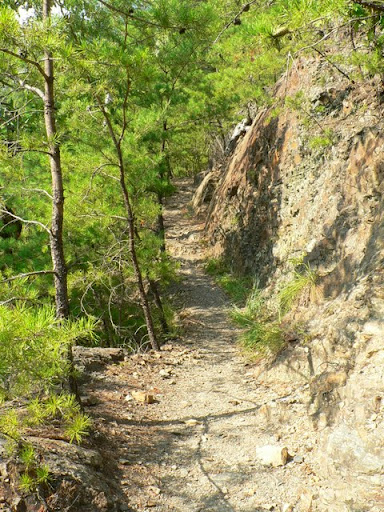
Enfin le plat ne dure pas, trés vite on attaque les lacets pour prendre de la hauteur. Ici la végétation est trés différente de ce que l'on trouve en général dans les montagnes de Caroline. Pour un peu on se serait cru sur la cote Méditerranéenne avec les pins et le sol sec.
However the flat doesn't last, quickly the switch-backs start to take you up. Here the vegetation is quite different from what is normally found in the Carolina's mountains. It almost felt like the Mediterrannean coast with the pine tree and dry ground.

Mais ce n'est pas pour la végétation que l'on fait cette randonnée. Non c'est pour la vue. Il y a plusieurs promontoires rocheux depuis lesquels il y a une vue incroyable sur la rivière. Bien sur il y a une légende, Cherokee, qui dit qu'une demoiselle c'est jetée depuis les rochers dans le vide après qu'un rival jaloux ait tué son amant.
But this hike isn't about the vegetation. No it's for the view, there are several rock promontories from which one can enjoy an incredible view over the river. Of course there is a legend, a Cherokee one, saying that a maiden threw herself off the rocks after a jealous man killed her lover.


Nous avons continué la randonnée sur la crête où la vue diminue mais l'ombre des arbres sait se faire apprécier.
Pour finir nous avons pris le sentier de Pump Gap afin de redescendre vers Hot Springs. Là on retrouve la végétation classique et luxuriante des montagnes, les larges rhododendrons en particulier.
We then continued onto the ridge where the view diminished but the shadow of the trees was enjoyable.
To finish we took Pump Gap trail to head back down to Hot Springs. That section of the trail got us back in the classic and lush mountain vegetation, especially the huge rhododendrons.

Au final la randonnée nous a pris à peine un peu plus de 2h, on marche bien, elle est rentrée à temps pour le repas et moi aussi.
In the end the hike took us barely over 2h, we walk at a good pace, she got back on time for dinner and so did I.

Aucun commentaire:
Enregistrer un commentaire